<< | >>


Copacabana peninsula seen from the Island of the Sun (Photo N.Brachet,1994)

Traditional fisher boat (Photo N.Brachet,1994)

Near Guaqui (Photo N.Brachet,1994)

Reeds of Titicaca lake (Photo N.Brachet,1994)

Village on the lake shore (Photo N.Brachet,1994)

Terrace cultivation on the Titicaca shore (Photo N.Brachet,1994)

Trout breeding near Tiquina (Photo N.Brachet,1994))

Between Huatajata and Copacabana (Photo N.Brachet,1994)

Cemetery of Tiquina (Photo N.Brachet,1994)

Cars crossing the strait of Tiquina (Photo N.Brachet,1994))

Passengers crossing the strait of Tiquina (Photo N.Brachet,1994)

Cholita waiting for the boat in Taquina (Photo N.Brachet,2003)

Strait of tiquina (Photo N.Brachet,2003)

Pier of Tiquina (Photo N.Brachet,2003)

Main square in Tiquina (Photo N.Brachet,2003)Back to the main page about Titicaca lake

Photo Gallery category "Titicaca lake"
Copacabana peninsula seen from the Island of the Sun (Photo N.Brachet,1994)
Traditional fisher boat (Photo N.Brachet,1994)
Near Guaqui (Photo N.Brachet,1994)
Reeds of Titicaca lake (Photo N.Brachet,1994)
Village on the lake shore (Photo N.Brachet,1994)
Terrace cultivation on the Titicaca shore (Photo N.Brachet,1994)
Trout breeding near Tiquina (Photo N.Brachet,1994))
Between Huatajata and Copacabana (Photo N.Brachet,1994)
Cemetery of Tiquina (Photo N.Brachet,1994)
Cars crossing the strait of Tiquina (Photo N.Brachet,1994))
Passengers crossing the strait of Tiquina (Photo N.Brachet,1994)
Cholita waiting for the boat in Taquina (Photo N.Brachet,2003)
Strait of tiquina (Photo N.Brachet,2003)
Pier of Tiquina (Photo N.Brachet,2003)
Main square in Tiquina (Photo N.Brachet,2003)
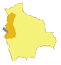
Department: La Paz
Altitude: 3810m
Length: 220km
Width: 110km
Altitude: 3810m
Length: 220km
Width: 110km
Photo Gallery


